Hebden Bridge Trail
- Paul Clarke
- May 31
- 7 min read

Hebden Bridge started life as a settlement based around the old bridge across Hebden Beck (also known as Hebden Water, or the River Hebden). The Hebden part of the town’s name comes from the Anglo-Saxon name “Heopa Denu”, which means bramble valley, whilst the bridge part is self-explanatory and we will cross the eponymous bridge on the walk. Like so many other towns in the West Riding, Hebden Bridge flourished during the Industrial Revolution, with water-powered mills built on its rivers and streams, and the opening of the Rochdale Canal through the town in 1804 allowed the produce of its wool trade to be shipped to both sides of the Pennines. Unusually, it lacks an historic Anglican Church, since it was originally served by the one in the nearby hilltop village of Heptonstall. As a side effect of the town’s post-industrial decline, rents plummeted, artists and bohemians saw opportunities and flocked to the town, establishing a acceptance of “alternative” lifestyles that eventually resulted in Hebden Bridge becoming known as "the lesbian capital of the UK". Still inclusive and welcoming, it is now a popular commuter town for people working in Bradford and Leeds, and is popular with tourists due to its picturesque setting. Like Sowerby Bridge, it was also used as a filming location and setting for Happy Valley, and its writer Sally Wainwright’s subsequent drama Riot Women.
Hebden Bridge Railway Station originally opened by the Manchester and Leeds Railway in 1840, although its Grade II-listed station buildings were not built and opened until 1893. Still in railway use, the well maintained station buildings include a staffed ticket office, waiting rooms, toilets and a café and make Hebden Bridge Railway Station one of the most handsome on the Calder Valley Line.

Hebden Bridge Railway Station.
From the main station entrance, we bear left towards the car park, then right along Station Road. This immediately crosses the River Calder via Victoria Bridge, the first of several Grade II-listed bridges in Hebden Bridge, which dates from 1851. Immediately after crossing the bridge, turn left along a footpath leading to a park and continue to a junction of paths, then turn left past the skatepark and café, eventually reaching the towpath of the Rochdale Canal.
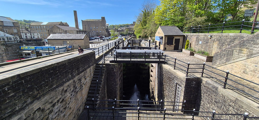
We turn left then immediately right across Blackpit Bridge No. 17, after which we turn left and continue along the towpath, passing Blackpit Lock No. 9 and then crossing Blackpit Aqueduct, also Grade II-listed and carrying the canal over the River Calder. Next, look out for Hebble End Works, a former dyeworks and textile mill, now used as a creative hub. Continue to the next bridge over the canal (Hebble End Bridge No. 18), then leave the towpath via a ramp up to Hebble End and turn right, crossing the Calder again over a further Grade II-listed bridge, which dates from the late eighteenth century was widened in 1806. Follow Hebble End to Market Street and then turn right.
Proceed along Market Street, looking out for a former Ebenezer Chapel on the left (built in 1777), immediately followed by the Old Gate bar and restaurant. Follow the street as it curves right and becomes West End, crossing a bridge over Hebden Beck (Grade II-listed again, and built in 1771-1772), which flows into the Calder a short distance to the right. Turn left along Bridge Gate and follow this to the Old Bridge, passing the White Swan public house on the right. The Old Bridge is Grade II*-listed, a Scheduled Ancient Monument, dates from c.1510, and is the bridge after which the town is named.

The Old Bridge.
Turn left over the bridge and continue straight ahead along Royd Terrace, before turning right along Hangingroyd Land. At the end of this, turn right and look out for the “Town Hall” (more formally the District Council Office) on the right, which was built in 1897. Immediately opposite this, the Millennium Clock can be seen on the wall of a building, and straight ahead St. George’s Bridge (Grade II-listed, of course, built of cast iron, and dating from 1892), crosses the beck.
Turn left opposite the Town Hall and follow Valley Road, eventually taking the third left into Moss Lane. Follow this increasingly steep lane uphill, and when it finally turns right and enters private property, continue straight ahead along a very steep footpath. When this ends at a drive, turn right and follow an even steeper cobbled path downhill (which gets quite slippery after rain), eventually looping back slightly to reach Hebden Beck, where yet another Grade II-listed bridge, Foster Mill Bridge, crosses it. This is a packhorse bridge probably dating from the late eighteenth century. Do not cross the bridge, but instead turn left and follow a path beside the beck. Follow the beck upstream, soon entering the edge of Lee Wood. On reaching a narrow concrete footbridge over the beck, cross this and on the other side turn left, continuing beside beck, and looking out for the weir of the now-demolished Lee Mill. Shortly after this, the path bends right and ends at Lee Mill Road. Cross straight ahead and climb stone steps up to a drive, then turn right and follow this to Midgehole Road. Turn right and follow this until it ends Keighley Road, then cross this and bear slightly left along Hurst Road, following this uphill as it passes between fields and ends at a row of houses. Proceed straight ahead along a footpath, gradually running downhill and offering excellent views to the right.
The path eventually enters Nutclough Woods, and ends at a junction, where the eighteenth century Hirst Bridge can be seen to the left, crossing the spring that runs down the valley. Turn right and follow a path beside the spring, looking out for the mill pond and dam that once provided water to the long-vanished Nutclough Saw Mill. Continue past the dam, eventually passing through a gate and joining the end of Nutclough Road. When this road (which is little more than a metalled track) ends at Wood End, turn left (the road immediately becomes Keighley Road) and then immediately bear right along Eiffel Buildings. To the right, on the other side Keighly Road, Nutcliffe Mill, which bears a blue plaque, can be seen. This mill is the former home of Hebden Bridge Fustian Manufacturing Society Ltd, which was founded in 1870 and was at the time the largest worker-producer co-operative in Britain.
Follow Eiffel Buildings, looking right for splendid views over the town, then when this ends turn left along Birchcliffe Road. This soon bends right and passes the former Birchcliffe Baptist Church on the left. This impressive building, now used as a conference centre, was built in 1898. Shortly after this, turn right into Birchcliffe Memorial Garden. The small garden was opened in 1961 and was gifted to the town by one Mrs Lilian Blackburn of Darlington who was born Hebden Bridge. It is dedicated to her elder daughter June Megan Blackburn, who died in 1932 at the tender age of nine years old. We turn left and cross the garden, then exit on Marlborough Road and turn right. Follow the steep road downhill until it ends at Osborne Street, then turn right, passing a former Zion Baptist Church on the left. When Osborne Street ends at School Street, turn left, passing Stubbings Infant School (an impressive building dating from 1878) on the right. At the end of School Street, cross straight ahead over Birchcliffe Road, then walk through a gap in the wall and follow a cobbled path to Keighley Road.
Cross the road and turn left, then turn right along Bridge Gate, passing the White Lion Hotel on the corner, immediately followed by Bridge Mill. The White Lion was originally a house built in 1657 and became a public house in the mid eighteenth century, before being substantially rebuilt late in the nineteenth century. The mill and its chimney, both Grade II-listed, were built c.1830. Continue to the Shoulder of Mutton Inn, then turn left into St. George’s Square, which is dominated by the Fustian Knife sculpture. Fustian knives were used in the manufacture of corduroy, for which Hebden Bridge once world-renowned. The sculpture is artist Mike Williams and was unveiled in 2008. It also serves as a giant sundial gnomon and points directly towards Nutclough Mill. Nearby Pecket Well mill was the last mill in Britain to manufacture corduroy fustian cloth. Continue across the square to Crown Street, and turn right, passing the large Co-Operative Hall on the opposite side of the road. Turn left into Cheetham Street, then at the end turn left again along Hope Street, passing Hebden Bridge Library on the corner. When Hope Street ends at Albert Street, turn right and follow this past the Albert public house, then when the road ends at New Road, turn right again.
Follow New Road, passing the Railway Inn on the right and Hebden Bridge Wharf on the left. The road next passes between Hope Baptist Church and Hebden Bridge Picture House. Unlike many of the old cinemas we have encountered in the West Riding thus far, this one (which opened in 1921 and is Grade II-listed) is still a cinema, and one of the last remaining council-owned ones in Britain. After passing the picture house, turn left into a memorial garden, and bear left past the war memorial, eventually leaving the garden via a path that crosses Hebden Bridge Wharf Footbridge No. 16A over the Rochdale Canal. On the other side, turn right and then sharp right to regain the towpath and follow the canal, again passing Hebden Bridge Wharf on the opposite side of the canal, followed by Crossley Mill, which is now a nursery. Shortly after the canal passes under Princess Bridge No. 16, we leave the towpath onto Mayroyd Lane and follow this as it curves right to cross Crow Nest Bridge over the River Calder. This is the final Grade II-listed bridge on the walk and dates from 1818. Finally, we continue straight ahead, and turn right in front of a bridge carrying the railway track over the footpath in order to return to the railway station.
From Hebden Bridge we return to the train and have one more stop to make in Calderdale, at the town of Todmorden.


Comments