
Todmorden Trail
- Paul Clarke
- May 31
- 7 min read

Our final station in Calderdale serves the town of Todmorden, located on the very western edge of Yorkshire and in fact straddling the historic boundary between Yorkshire and Lancashire, which is formed at this point by Walsden Water, a tributary of the River Calder. The Local Government Act 1888 moved the official boundary, bringing the whole of the town into the West Riding of Yorkshire, and of course today is falls within the Metropolitan and Ceremonial County of West Yorkshire. Technically, the station is therefore located in the Historic County of Lancashire, and the walk – like the town – straddles both counties. Todmorden’s location at the confluence of three valleys meant that an abundance of streams lent themselves to water power, with corn and fulling mills giving way to a large cotton industry during the Industrial Revolution; the town once had the largest weaving shed in the world. Todmorden is long considered the safest accessible route across the Pennines, and the nineteenth century saw the coming of the Rochdale Canal, the railway and improvement to the turnpike roads through the town. Today, the town’s industry is largely a thing of the past, but it remains lively, in part thanks to its popular market.
Todmorden Railway Station was opened in 1841 by the Manchester and Leeds Railway and has retained its original buildings, which are currently home to an art gallery and creative studio. The subway exit from platform 1 also boasts a blue plaque commemorating railway engineer John Ramsbottom (1814-1897), who was born in the town. From the main entrance of the station, we bear left to Station Approach, where the Queens Hotel can be seen directly opposite. From here, turn right and follow Rise Lane, looking over the wall on the right for a glimpse of Todmorden Hall, a Grade II*-listed building dating from the early seventeenth century. When Rise Lane ends at Rochdale Road, turn right, shortly passing Todmorden Library on the right hand side of the road. Just past this, follow the road as it crosses the Rochdale Canal via Todmorden Changeline (or Golden Lion) Bridge No. 30, then turn right to gain the towpath.
Follow the canal, immediately passing the unusual Todmorden or Library Lock No. 19, the bottom gate of which is a guillotine gate. It was originally built as a conventional lock, but following the canal’s closure, Rochdale Road – and thus the bridge – was widened, leaving no room for standard lock gates. Thus, the guillotine gate was the novel solution arrived at during the canal restoration effort.
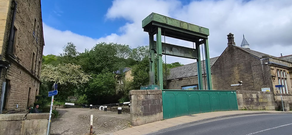
Todmorden or Library Lock No. 19.
Not long after the lock, the canal bends left, where the imposing “Great Wall of Tod” can be seen on the other side of the canal. This was built in 1881 to support the expansion of the railway station’s goods yards and is believed to contain more than four million bricks. Shortly after the wall ends, the canal passes under Bridge No. 30A, which carries Dobroyd Road. It then begins to climb as it starts to head towards its summit pound, passing through Wadsworth Mill Lock No, 20 and Shade Lock No. 21, before passing under Gauxholme Railway Viaduct, which is Grade II listed and was built in 1840 by George Stephenson to carry the Manchester and Leeds Railway. It is a cast iron span, but is especially striking due to its semi-octagonal towers.
Continue along the canal, which passes through Gauxholme Lowest Lock No. 22 and Gauxholme Middle Lock No. 23. It then passes under Gauxholme Arch Bridge No. 31 to reach Gauxholme Highest Lock No. 24; here, turn sharp left and leave the towpath by walking up the ramp to Bacup Road. This is as far as we shall follow the Rochdale Canal in our railway tour of Yorkshire; from here, it climbs to its summit pound in the Pennines, before beginning its long, slow descent towards Manchester, where it finally ends at its junction with the Bridgewater Canal. Once on Bacup Road, we turn left onto Bridge No. 31, and then immediately turn right along Pexwood Road and follow this as it runs uphill through trees, eventually reaching the entrance lodge to Dobroyd Castle. Despite its name, the Grade II*-listed “castle” was actually built as a mansion house for local mill owner John Fielden between 1866 and 1869, and has since served as a school and a Buddhist Retreat. Currently, it is used as an activity centre for primary school groups. Turn left and follow Stones Road, which soon takes a hairpin bend to the right, before turning left again and eventually ending at Stones Farm. Here, turn right and follow a waymarked public footpath, which forms part of the circular, fifty-mile Calderdale Way.
As we follow the footpath, we soon pass Dobroyd Castle Model Farm on the right, which is Grade II-listed and was built in a similar architectural style to the castle. On reaching a wooden stile, climb over this and continue straight ahead for a short distance, then bear right and climb over another stile to follow a footpath along a field edge to a copse of trees, looking right for a view of Dobroyd Castle. Climb over another stile and continue to follow the path past the copse and along the edges of two more fields, eventually reaching Doghouse Lane. Turn right, then after short distance turn left to a follow a path that runs downhill through Buckley Wood. When stone steps appear on the right, descend these, then turn left. Continue to another set of steps on the right and descend these, continuing straight ahead at the bottom to leave the woods and enter Centre Vale Park. This was originally the estate of Centre Vale House, once home to “Honest” John Fielden (1784-1849), a British industrialist and Radical Member of Parliament for Oldham. The estate was gifted to Todmorden Borough Council c.1900 and opened as a public park in 1912. Centre Vale House is long-since demolished, but the remains of the coach house can still be seen.
When the path ends at a junction, turn right and then left to visit the remains of the coach house. Walk through the adjacent courtyard, then take a short detour to the left to visit Todmorden War Memorial. Located in a garden of remembrance, this rather impressive memorial dates from 1921 and comprises an ornate ornamental fountain sculptured by Gilbert William Bayes, located in front a wall bearing tablets inscribed with names of the fallen. After visiting the memorial, we return to the path, then turn left and walk clockwise around the park, detouring left at the bowling greens for a view of Fielden School of Art, a Grade II-listed building dating from c.1871. Continue the circuit of the park, next passing the bandstand, soon following by the Taplin Memorial. Turn right past this and follow a path next to Todmorden Cricket Club on the left. When the path enters Buckley Wood, turn left and follow the path to Christ Church. Turn left through a gap in the wall just before this to enter the churchyard, then bear right to leave close the lychgate leading to the church. This is a Grade II-listed former church built in 1832 and is now a private residence.
Turn left and follow Vicarage Gardens, then turn right along Burnley Road. When the tiny Patmos Park appears on the left, follow a path that loops through this, to see the Patmos Men Memorial. Immediately after leaving the park, turn left and leave Burnley Road, following a footpath that forms part of Coupland Street. This bends right and becomes a cobbled street between houses, shortly ending at Stansfield Road. Cross this and follow a path alongside the River Calder, passing underneath a railway viaduct to reach Todmorden Market. Walk anticlockwise around the Market Hall, looking right across a car park to see the Central Methodist Church. Cross a footbridge back across the river, then turn right and follow a tarmacked track until it joins the end of Hallroyd Crescent. Follow the crescent as it bends right, then when it turns left bear right along a path to reach Halifax Road.
Turn right over a bridge across the river, then immediately turn left along Key Sike Lane and follow this until it reaches Kilnhurst Bridge No. 28 over the Rochdale Canal. Turn right to return to the towpath, and follow the canal as it passes under Baltimore Bridge No. 29 before reaching Shop Lock No. 18. Continue past this back to Todmorden Changeline or Golden Lion Bridge No. 30, just before which the Golden Lion Hotel can be seen on the far side of the canal. This is a Grade II-listed public house dating from the mid-eighteenth century, which gives the bridge its alternative name. Walk through the cobbled horse tunnel under the bridge, then turn right to leave the towpath and return to Rochdale Road. Thus, we part company with the Rochdale Canal for the final time.
After leaving the canal, we turn left, then bear right along Water Street, which runs to the right of Walsden Water, and follow this to Halifax Road. On reaching Halifax Road, look left to see the Church of St. Mary on the far side of the nearby roundabout. The second Grade II-listed church on the walk, this was built in 1770 with the chancel added in 1896. Cross Halifax Road at the pedestrian crossing, then turn left and walk to the roundabout and turn right along Burnley Road. On the corner of Halifax Road and Burnley Road, Todmorden Town Hall can be seen. Easily the town’s most impressive building, the Grade I-listed neoclassical ashlar stone town hall was built in 1875 and straddles Walsden Water and thus the historic county boundary.

Todmorden Town Hall.
Continue past the town hall, then cross over and turn left into Ridge Road, immediately bearing left along White Fold, which runs between Todmorden Masonic Hall on the left and the White Hart public house on the right. At the end of White Fold, climb steps to reach Station Approach, and finally turn left to return to the railway station.
Todmorden ends our railway tour of the Metropolitan Borough of Calderdale, and indeed the Ceremonial County of West Yorkshire. But we are by no means finished exploring the historic West Riding, as we head back to Leeds and from there venture into North Yorkshire…


Comments