
Sowerby Bridge Trail
- Paul Clarke
- May 29
- 8 min read

The town of Sowerby Bridge started life as a fording point over the River Calder, close to where it is joined by the River Ryburn. More so even than its neighbouring West Riding towns, it expanded during the Industrial Revolution, with water-powered textile mills erected around the bridge and the opening of the Rochdale Canal providing a route for transport by water over the Pennines. As such, most of its oldest buildings date from the nineteenth century rather than earlier. Whilst the town’s textile industry is long gone, Sowerby Bridge continues thrives as a commuter town and the canal remains a popular cruising route. It is also now well known as the setting of the BBC drama series Happy Valley, much of which was filmed in the town. It also boasts several listed bridges over its two rivers and the canal.
Sowerby Bridge railway station originally opened in 1840 on the Manchester and Leeds Railway, 662 yards from its current location, on the other side of the River Ryburn. It was re-sited in 1876 when it became a junction. Most of the original station buildings were destroyed by a fire in 1978, although the ticket office survived. We leave the station via Platform 1 and turn right along Station Road, passing the aforementioned former ticket office, which is now a café. A blue plaque on the wall notes that Branwell Brontë – poet and only brother of the better-known Brontë sisters – worked briefly at the station. Continue straight ahead at a crossroads, looking out for a former Post Office on the left. When the road ends at West Street, it is worth taking a detour to the right under the railway line to view County Bridge, which dates from the mid-seventeenth century, is built on the site of an earlier bridge, and is the bridge after which the town is named. At the far end of the bridge, the former Town Hall can be seen at the far end, Grade II-listed and dating from 1856.
Detour over, from the end West Street we turn left and then take the next left along Water Street, passing the Loose Goose public house on the corner. Directly opposite this, on the other side of West Street, the former Royal Hotel can be seen at the junction with Sowerby Street; a striking nineteenth century building, it is notable for its rounded corner bay at the junction. Follow Water Street to Victoria Bridge, which crosses the River Ryburn, cross this, and then turn right. Less well known than the Calder, this river is only a little over seven miles long and rises close to Blackstone Edge. Follow the riverside path to the next bridge, Stirk Bridge, which carries Bridge Street over the river; both Victoria Bridge and Stirk Bridge are constructed from stone and cast iron, date from the nineteenth century, and are Grade II-listed. Cross the bridge and continue to a crossroads, then continue straight ahead along Foundry Street, passing for a former Wesleyan Mission chapel (now community centre) on the right. When the road ends at a slightly staggered crossroads, continue straight ahead along Sowerby New Road and follow this as it climbs uphill, before taking the sixth right turn along Cemetery Lane and follow this to Sowerby Bridge Cemetery. Take an optional detour to explore the cemetery, which includes a lodge and cemetery chapel (Grade II-listed and built in the mid-late nineteenth century); otherwise turn right.
Follow the path until it reaches a fork, then bear left. Stay on the path as it curves further left, soon running between allotments on the left and Dixon Scar Woods on the right. We now take the next right turn and follow a path through the woods, as we start the most rural stretch of the walk. The path continues to gradually loop round to the left, and then soon climbs as it gets closer to the River Calder, becoming steep and narrow, before gradually descending to the riverbank. This is not a footpath for anyone who lacks a head for heights, with an often steep drop down towards the river on the right. Continue to follow the for approximately half a mile, until a footbridge over the River Calder appears on the right, then cross this, looking upstream for a view of one of the two Tenterfields weirs. At the end of the bridge, continue straight ahead along a path, passing the entrance to an industrial premises on the left. Continue straight ahead past this, where the path climbs the embankment of the Rochdale Canal to reach the towpath close to Longbottom Bridge No. 4.
The Rochdale Canal is a 32 mile long broad canal that connects the Bridgewater Canal with the Calder and Hebble Navigation, and along with the Huddersfield Narrow Canal and the Leeds and Liverpool Canal (both of which we have already encountered), is one of three main canal routes across the Pennines. It was completed in 1804 and closed in 1952; like the Huddersfield Narrow Canal, it subsequently become derelict, but a herculean restoration effort driven by the Rochdale Canal Trust eventually saw the canal fully reopened to navigation in 2002. We will follow the towpath back to its junction with the Calder and Hebble Navigation, and later see more of it on the final three walks in Calderdale. Proceed along the towpath for one and a quarter miles, during which the canal passes beneath High Royd Bridge No. 3, Sowerby Long Bridge No. 2, and then Sowerby Footbridge, before passing the imposing Hollins Mill on the right. The canal then passes under Tower Hill Bridge No. 1A, before reaching a locked gate, where the towpath continues to Tuel Lane Lock No. 3/4. Here, bear right through a gap in the wall and follow a car park to Tuel Lane, looking left for a view of the lock, which was built in 1996 during restoration of the canal. It replaced the original locks No. 3 and 4 and is the deepest lock in the United Kingdom. Because of its depth, it may only be operated by a lock keeper, and makes for an impressive sight.
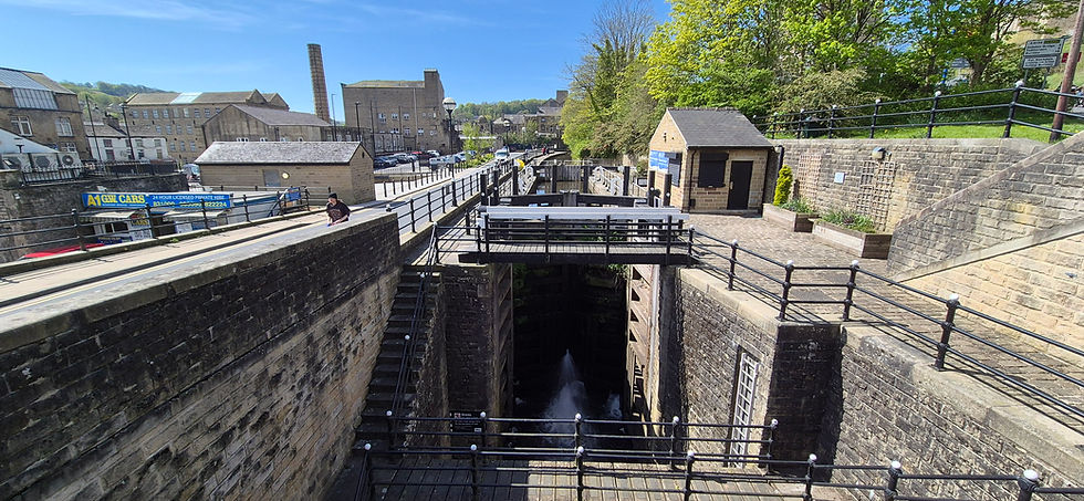
Tuel Lane Lock No. 3/4.
From the lock, we turn right and follow Tuel Lane to Wharf Street, passing Christ Church on the left, Grade II-listed and built in 1819. The Commercial Inn – owner by Wetherspoons – is located opposite the church, on the corner of Tuel Lane and Wharf Street, for anyone in need of refreshments. Cross Wharf Street and turn left, then turn right to regain the canal towpath. Just before this, take a short detour further along Wharf Street at this point to see the former Roxy Cinema on the right. This originally opened in 1915 as the Electric Theatre, was renamed the Roxy Cinema in 1952, and finally closed in 1963. Almost inevitably, it later become a bingo club, then nightclub and bar. Proceed along the towpath, looking back to see the entrance to Tuel Lane Tunnel No. 1, which was dug beneath Wharf Street during the canal restoration and provides an example of the sort of challenges faced and overcome by the Rochdale Canal Trust! Continue past Second Sowerby Bridge Lock No. 2 to Albert Wood Lock No. 1, then cross the canal via the lock bridge, pausing to look downstream for a view of the Salt Warehouse.
We have now almost reached the start of the Rochdale Canal, at its junction with the end of the Calder and Hebble Navigation. Continue straight ahead past the former West Warehouse (which now houses the Moorings public house), then take another detour (this time straight ahead) to see the Wharf House (now a café) at the junction with Wharf Street, close to which the Jack o’ the Locks sculpture can be seen. Turn right past the Moorings, looking out for the former Weigh-house, and continue past Sowerby Basin on the right, which marks the terminus of the Calder and Hebble Navigation. Many of the buildings around the basin are Grade II-listed, including the Salt Warehouse, the West Warehouse, the Wharf House, and the Weigh-house, whilst the Wet Dock (visible across the basin from the path) is Grade II*-listed. The former Bolton Brow Methodist Church and Canal Warehouse (also Grade II-listed) towers over the basin on the left-hand side of the path. Continue until the path ends at Gas Works Road Bridge, looking across the navigation just before reaching this to see the start of the Rochdale Canal.
The walk now leads us out of town, for a visit to one of Calderdale’s most distinctive landmarks. We turn left along Chapel Lane, passing the Navigation public house on the right (a mid-seventeenth century house converted into a pub during the nineteenth century), and follow it until it ends at Bolton Brow. Here, turn right and follow this past the Shepherds Rest public house on the left, and on reaching a mini roundabout, bear right along Pye Nest Road. Follow this for about half a mile, then turn right along Edwards Road. When this ends at a junction, turn left past the Wainhouse Tavern (built in 1877 as a house named Westair and later the Royal Public House) and immediately turn right to follow the cobbled Stoney Lane steeply uphill until it ends at a road called simply Gainest. Turn left and walk to a set of steps leading up to Rochdale Road, then turn right and very shortly turn right again along a public footpath. Follow this between trees, with a cemetery on the right, eventually reaching a grassy open space, where Wainhouse Tower stands. This hugely impressive Grade II*-listed tower is a prominent local landmark and is the tallest folly in the world. It was originally built between 1871 and 1875 and was designed by architect Isaac Booth as a chimney intended to serve John Edward Wainhouse’s dye works on Washer Lane. Instead, Wainhouse sold the dye works and kept the chimney, using it as an observatory and adding viewing platforms. For anyone wishing to see the view from the top, the tower is usually open on bank holidays, and a climb up 369 steps provides access to the lower of two viewing platforms. A further 36 steps leads to the higher viewing platform, although this is usually closed to the public.
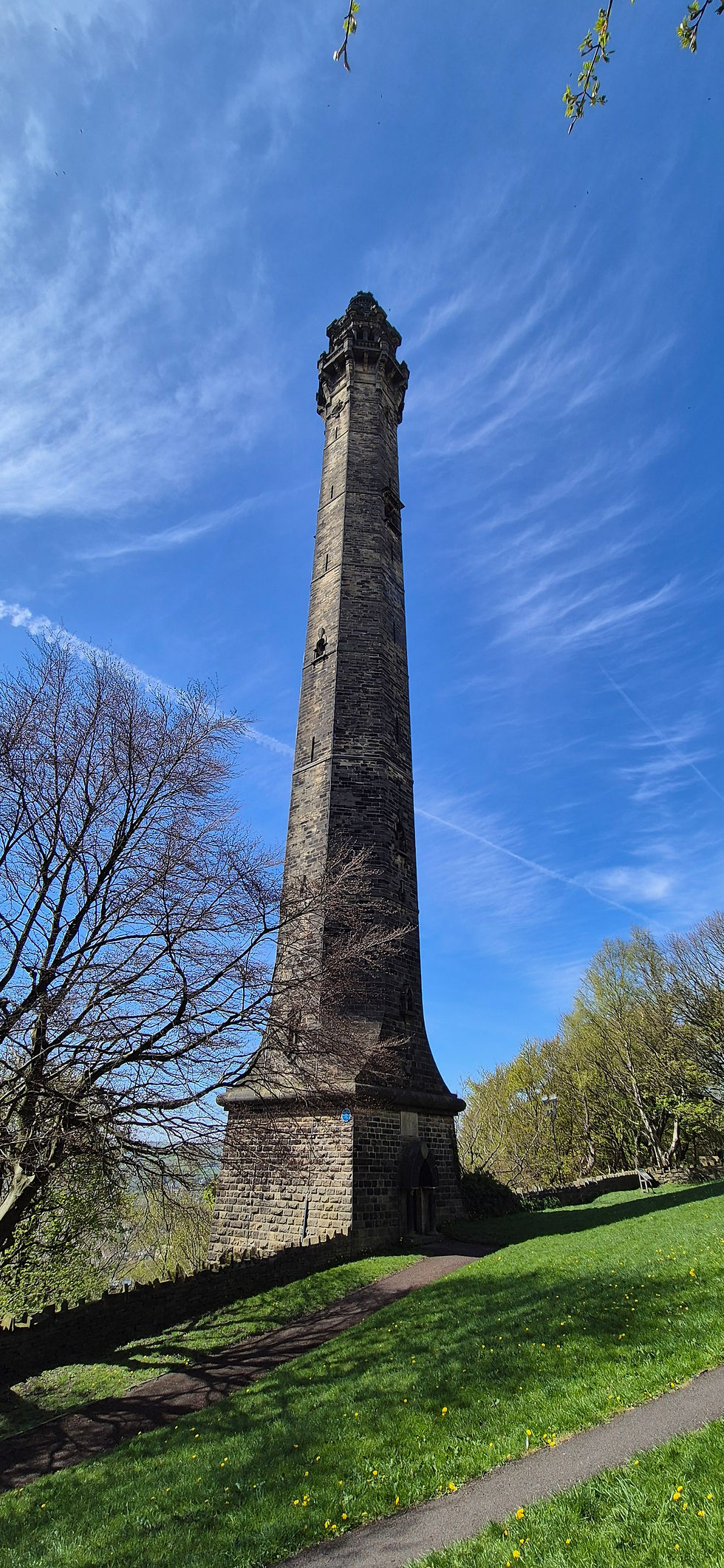
Wainhouse Tower.
From the tower, continue straight ahead, eventually reaching Wakefield Gate. Turn right and follow this downhill to a crossroads, then continue straight ahead along Upper Washer Lane. When this ends at a junction (close to the Wainhouse Tavern), we turn left and follow Washer Lane downhill, all the way until it eventually ends at Wakefield Road. We Cross this and continue straight ahead along Canal Road until it reaches Fall Lane Bridge over the River Calder, yet another of the town’s Grade II-listed bridge, dating from c.1800. Cross the bridge, looking right upstream for a view of Mearclough Weir, and walk to the end of Fall Lane. Finally, we turn right and follow Mearclough Road, which soon becomes Holmes Road, and stay on this until steps on the left lead up to Sowerby Bridge Railway Station, on the opposite side of the railway line from which we started the walk.
From Sowerby Bridge, we continue further along the Calder Valley Line, enjoying the scenery as it continues to climb into the Pennines. After the nineteenth century industrial architecture of Sowerby Bridge, our next walk is far more rural in nature, as we reach the village of Mytholmroyd.


Comments